Our Heritage Timeline
Cleaven Dyke
Cleaven Dyke
A prehistoric mystery hidden in plain sight
Video courtesy of Graeme Berry/Isla Aerial Surveying & Imaging
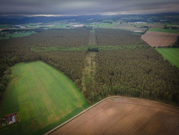
Cutting across the A93 between Meikleour and Blairgowrie, Cleaven Dyke is the finest prehistoric monument of its type in Britain. It is a vast earthwork measuring some 2.6km long, averaging 9m wide and 1.8m high in places - you've probably driven past it and not realised!
Definitions:
Dyke - usually means a wall or embankment to prevent flooding.
Cleave - to cleave means to divide.
Cleaven Dyke was thought to be a Roman defensive structure, possibly linked to the Roman forts at Inchtuthil and Meikleour. However, excavations carried out in 1993 revealed it to be a Neolithic Cursus. The purpose of a cursus is open to debate, but it may have been a ritual monument or perhaps a processional route.
Whatever its purpose, it would no doubt have been of deep significance to its builders. There is no signpost at this location, and many people pass it without knowing of its existence. However, the Cleaven Dyke, perhaps the area’s best kept secret, is regarded as a monument of national importance.
Video credit - Graeme Berry/Isla Aerial Surveying & Imaging
Video credit - Graeme Berry/Isla Aerial Surveying & Imaging
Read more at Canmore website
How to find Cleaven Dyke:
From Blairgowrie and Rattray take the A93 south towards Perth, through Carsie to the long straight through Meikleour woods. Approximately 500m into the woods looking left or right there is a gap in the trees stretching into the distance. This is the Cleaven Dyke.
OBSERVE THE SCOTTISH OUTDOOR ACCESS CODE AT ALL TIMES. Visit www.outdooraccess-scotland.com
Previous Page