Our Heritage Timeline
500 Million Years Ago
500 Million Years Ago
Scotland used to be located at the South Pole
Perthshire is sometimes referred to as a gateway to the Highlands, and if you look at a map of Scotland it’s easy to see why. To the south and east are the gently rolling farmlands of the Strathmore Valley, Angus, and the Mearns; while to the north and west lie the dramatic and inhospitable heights of the Cairngorms and the Monadhliath. From its location on the northern edge of the Strathmore Valley, Blairgowrie makes an ideal vantage point to observe this contrast.
So what is behind, or in this case beneath, this dramatic and sudden change in the landscape?
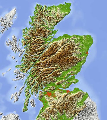
Highland Boundary Fault
To find out we have to look far back into the past, to the formation of the planet itself hundreds of millions of years ago. As the mass of molten rock that was to become the earth cooled, it formed into three layers.
In the centre is a CORE of molten metal, a thick layer of melted, liquid rock known as the MANTLE, and a thin surface of cooled rock called the CRUST. This crust is made up of large chunks of rock called TECTONIC PLATES, which float on the molten rock of the mantle, called MAGMA.
Over millions of years, these plates move around, in a process called CONTINENTAL DRIFT. This process is driven by gravity and by the rotation of the earth itself.
Present day Scotland lies on the Eurasian Plate, a vast raft of rock that stretches from Iceland to Japan, but which was once located at the south pole as part of a prehistoric supercontinent known as Pangaea.
These movements create immense forces capable of splitting apart the rocks of the crust, creating fractures known as FAULT LINES. While the most active fault lines are associated with earthquakes, tsunamis and volcanos, others can be seen less dramatically in the mixing of layers of different rock types.
One such dormant fault line, the Highland Boundary Fault, runs across Scotland from the shores of Loch Lomond in the southwest all the way to Stonehaven in Aberdeenshire passing just north of Blairgowrie.
The southerly rocks are sandstones and other soft, sedimentary rock types, which give Strathmore and Mearns some of the most fertile farmland in Scotland. North of the faultline are the hard, metamorphic schists and slates of the DALRADIAN SUPERGROUP, which render the landscape far less suitable for arable farming.
Because this underlying geology has a profound effect on the uses to which the land can be put, the fault line also represents a cultural boundary between the more feudal arable farming culture of the Lowlands and the wilder, more warlike Highland culture of Clans and Caterans.
Since conditions in the south were more favourable to development, this geology laid the foundations for the demographic and economic makeup of Scotland which persists to this day with the majority of the population concentrated in the central belt.
The zone of the fault itself, known as the HIGHLAND BORDER COMPLEX can be seen in the physical features of the landscape as well as the culture. The complex intermixed geology of this area can be seen in the steep sided Craighall Gorge north of Blairgowrie and Rattray, the spectacular Reekie Linn waterfall in Glenisla, and even the wide expanse of Strathmore (from Gaelic “An Srath Mòr” , or “big valley”).
Being located almost perfectly at the border of these two distinct geological as well as cultural zones made Blairgowrie a literal gateway and trading post, with the local culture and economy being influenced by both Lowland and Highland traditions.
Further Information/Sources
https://en.wikipedia.org/wiki/Highland_Boundary_Fault
https://www.scotlandinfo.eu/the-highland-boundary-fault-line/
https://cateranecomuseum.co.uk/site/the-highland-boundary-fault/
http://mapapps.bgs.ac.uk/geologyofbritain3d/
Youtube : Scotland's Geological History - Taylor Bryant
How To Find Craighall Gorge:
Craighall Gorge can be accessed from the A93 just north of Blairgowrie and Rattray, however limited parking is available and it is best accessed on foot from the town centre. The signposted route is shown on the Blairgowrie Path Network maps, and is sign posted. The route is also detailed on the Perth & Kinross Council - Core Paths Plan interactive map (Craighall Bridge to A93 via Middle Mause).
The core path route runs on well surfaced paths and the former A93 which closed in 2008. Away from the path network, terrain in this area is steep, with very limited access and is also a "Site of Special Scientific Interest" so venturing off the paths is not recommended.
For the more adventurous, river tours in the areas are available from Outdoor Explore | Kayaking in Scotland.How To Find Reekie Linn:
Reekie Linn can be accessed from the carpark at Bridge of Craigisla around 4 miles north of Alyth on the B954. A riverside path leads to the waterfall, and this is narrow and steep in places, with unexpected drops.
Walkhighlands Reekie Linn InformationHow To Find Viewpoints for Strathmore Valley and The Boundary Fault Landscape
The Knockie, Blairgowrie:
Access from Blairgowrie by following the marked “Knockie Path” route which forms part of the Blairgowrie Path Network. This is a short walk on good paths and offers views south over the Strathmore valley and the Sidlaws.
Lundy Craigs, Hallyburton:
Hallyburton Hill can be accessed from “Hallyburton Community Woodland” car park on the A923 Coupar Angus to Dundee road. Access is mostly easy forestry roads however there are in some areas narrow cliff paths and steep sections where caution should be exercised.
Hallyburton and the adjacent Northballo hill are popular areas for mountain biking with a variety of downhill trails suitable for intermediate to advanced riders. Further details are available from the Coupar Angus Cycling Hub.
Mount Blair, Glen Isla:
Offering spectacular 360 degree views of Strathmore and the Cairngorms, Mount Blair can be accessed from a small car park on the B951 between Glenshee and Glenisla. Access to the summit is via Land Rover track, and is not recommended for those unfamiliar and unequipped for hillwalking in rough and remote mountain terrain.
Walkhighlands Mount Blair Information
Cairnwell Chairlift, Glenshee Ski Centre:
The summit of The Cairnwell on the Perthshire/Aberdeenshire border offers views over Perthshire with access via chairlift from Glenshee Ski Centre in the summer months (weather permitting).
Please visit Glenshee Ski Centre for details and opening times.
VISITORS ARE REMINDED TO PARK VEHICLES RESPONSIBLY AND OBSERVE THE SCOTTISH OUTDOOR ACCESS CODE AT ALL TIMES. Visit www.outdooraccess-scotland.com
Previous Page